


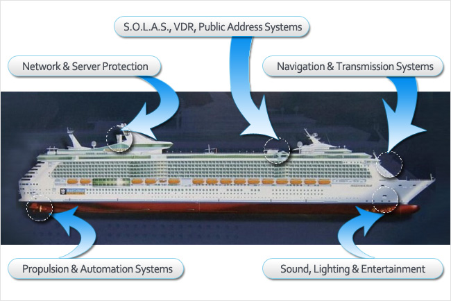
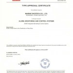
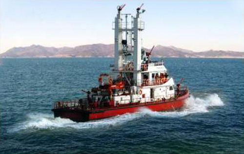
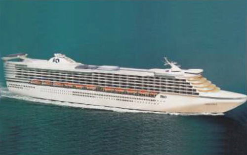
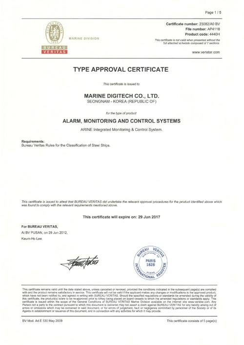
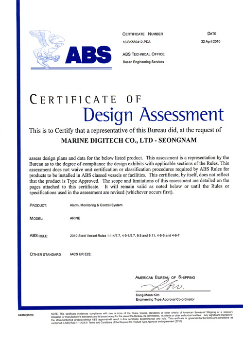
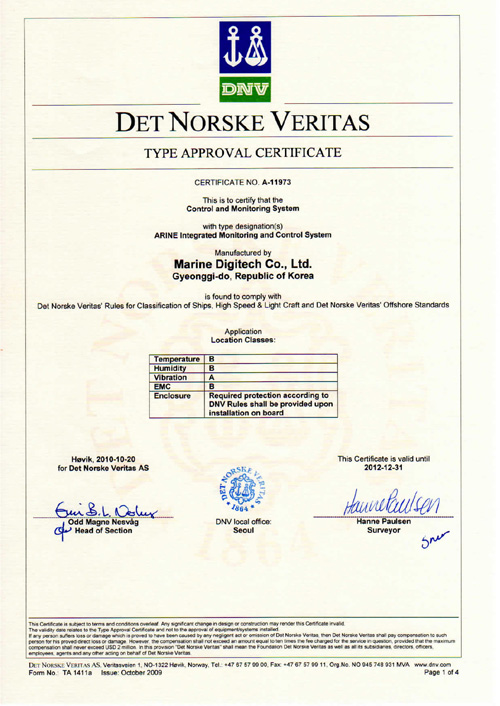
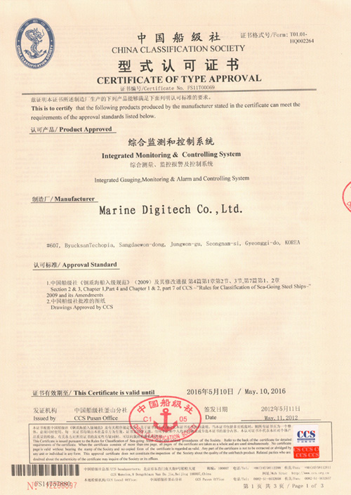
The ARINE is a system that control ship-related automation and cargo monitoring. The system is designed provide an optimal solution to middle / small scale applications. Also, the system open structure allows easy integration with international / industry standards, and providers a foundation for high-reliability and maintainability.
Marine Control Systems
- Home
- Marine Control Systems
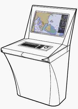
NAVIK-ECDIS
Electronic Chart Display & Information System
NAVIK-ECDIS is an Electronic Chart Display and Information System, which assists navigation and improves safety. It provides voyage information such as position, course and speed. In addition, it includes convenient route planning functions, which introduce optimal navigation paths. NAVIK-ECDIS is suitable for both new build vessels and retrofit installations.
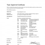
NAVIK-ECDIS is designed to ensure full compliance with the latest standards of IMO, IHO and IEC. It was type approved by Classification Society and uses the electronic charts which are compatible with ENC (S-57 Ed 3.1) charts, C-Map CM-ENC and RNC charts.
The ENC/RNC kernel, which is developed by Marine Digitech, fits all types of performance regulations. This improves processing rate of both the representation and management regarding electronic charts.
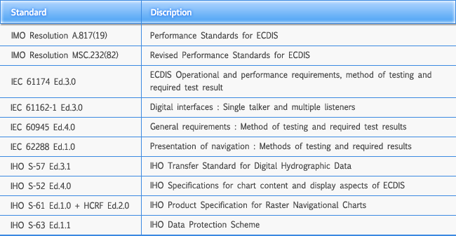
NAVIK-ECDIS conforms to the requirements of following standards :
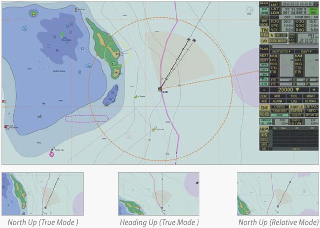
PRECISE AND SOPHISTICATED PRESENTATION
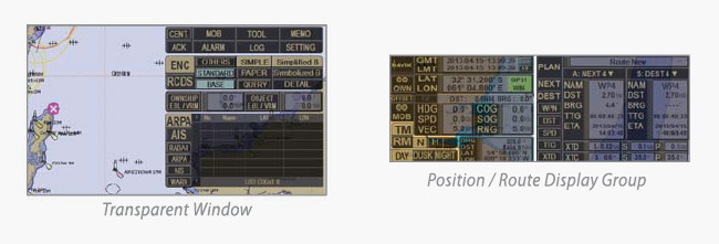
Displayed on the map are a variety of navigation information, such as ship position, heading, speed, COD and SOG. All the windows are transparent, thus ensuring the maximum vision of chart areas. Moreover, NAVIL-ECDIS provides multiple backgrounds in response to weather conditions (Day, Dusk, Night), in several different modes (North/Head-Up, True/Relative Mode). Included is special chart dictionary with comes along wiht the query function to help the understanding of ENC information.
No additional manuals are needed.
ELABORATE CONDUCT AND DISPLAY OF OTHER VESSELS
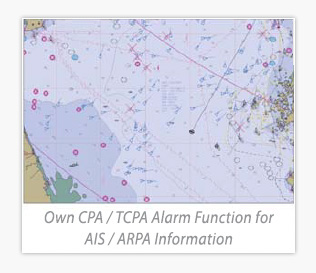
NAVIK-ECDIS display information of up to 300 vessels within the range the user has defined. The information is collected from AIS and ARPA, such as position, speed, direction, distance, and bearing. Especially, CPA/TCAP alarm can be calculated by its own functions and also by the previous events recorded. The recording of the events has no limitation.
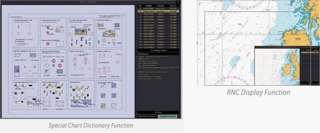
DIVERSE FUNCTIONS WITH QUICK-SEARCHING LIBRARY
NAVIK-ECDIS used ENC/RNC/DXF kernel library which is developed by Marine Digitech.
The library supports diverse special functions with quick search of information, and meets the needs of each user by selecting the appropriate data the situation demands.
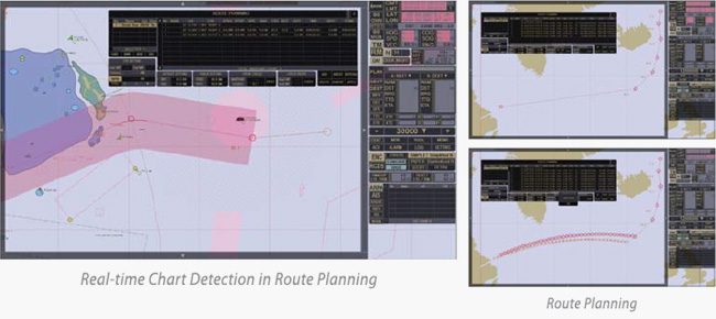
EASY ROUTE PLANNING WITH REAL-TIME CHART DETECHION & MONITORING
NAVIK-ECDIS provides advanced route planning, real-time chart detection and route monitoring. By using either a trackball or keypad, planning of routes and setting of waypoints are done readily. Accordingly, the operator can determine routes with ease and preciseness.
Even during the voyage, the operator can add or change to alternative routes by simple addition, alteration, insertion, and deletion of waypoints. Moreover, it offers automatic monitoring to real-time voyage route.
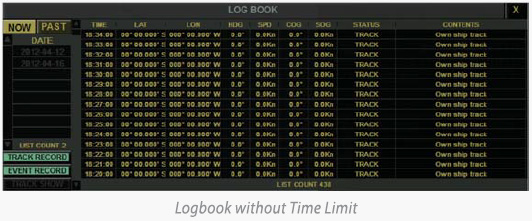
THOROUGH RECORDING AND PLAYBACK OF VOYAGE DATA
The voyage date are recorded without the limitation of time. They include clock. GPS, ship position, heading and speed, which can be played repeatedly by the playback function.
Furthermore, log data files can be exported for the display on other computers.
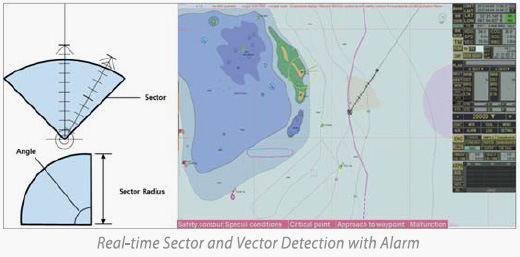
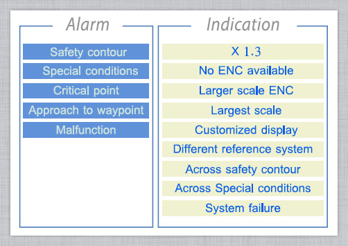
DISTINCT NAVIGATION ALARMS
NAVIIK-ECDIS provides distinct audible and visible navigation alarms, for situations such as anti-grounding, collision, cross track and the loss of sensor data.
SYSTEM INTEGATION AND SHARING OF NAVIGATION DATA
NAVIK-ECDIS interfaces with many existing bridge systems and navigation equipment for the exchange of navigation data. Dual NAVIL-ECDIS system (master and back-up) shares the identical data from ARPA, autopilot, AIS, echo sounder, speed log, and wind speed direction sensor.
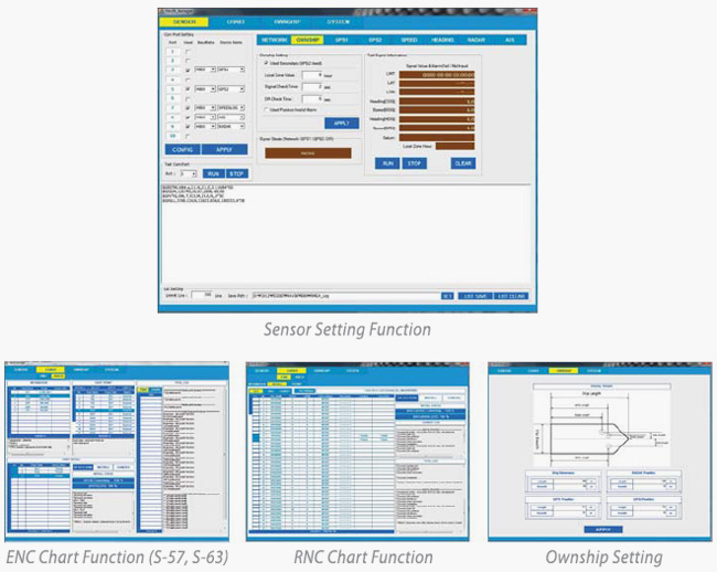
EASY INSTALLATION AND CONTROL WITH NAVIK-MANAGER
NAVIK-MANAGER’S main function is to control the mechanisms elated to the signal of sensors connected to NAVIK-ECIDS. NAVIK-MANAGER can install NAVIK-ECDIS very easily, and also supports permit to chart, management of install/update, set-ups, size-setting of monitor display and system test functions.
OPTIONAL RUNCTIONS
NAVIK-ECDIS provides varied special options. They improve safety and efficiency of ship operation further, not to mention the various weather forecasting and navigation information.
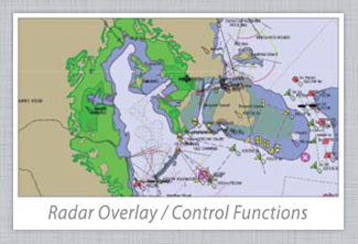
- RADAR OVERLAY
- DXF OVERLAY
- CONNING DISPLAY
- TRACK CONTROL WITH AUTOPILOT
- WEATHER FORECASTING INFORMATION
- NAVETX INTERGRATION
- PIP FUNCTION
Dynamic Positioning System (DPS)
Norr Systems announces joint venture with EMI
for the Dynamic Positioning System
We are very pleased to announce of the successful joint venture of our company with Engine Monitor Inc. (EMI) – an official DP maker in the US. Jointly developed by the two companies, Norr P-Class Dynamic Positioning made it possible to deliver the most versatile solution with ready interface for retrofit and new buildings.
Norr Systems has an unrivalled experience in design, manufacturing, and services solutions for marine and offshore industries. This comprises a strong fundamental for the company’s endeavor to venture into manufacturing and complete systems integration. On the other hand, EMI has a long history of service offerings to the marine industry through state-of-the-art engineering and manufacturing to USbased clients. The resulting entity of the joint venture is aimed at delivering new DP System with improved features.
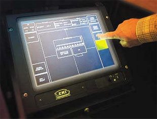
User Graphics Interface designed with simple operator touch screen operability
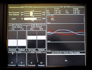
Signal monitor in Night Reverse Color Display shows thruster command and feedback with roll/pitch and list/trim displays
Norr P-Class Dynamic Positioning Features:
- DP algorithms based on proven PID Controller/ Feedback technology and ship’s model with built-in Kalman filter
- The platform for the software is a LINUX Operating System
- The program is written in the JAVAPC software code
- The system uses a TCP/UDP/IP interfaced client/server network for continuous rapid communications between the server and the clients
- The TCP/IP further allows for remote telnet access for remote diagnostics
- Optional feature to telnet is the Cellular or Satellite phone system
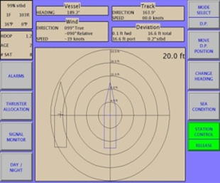
The display for the DP mode shows a visual indication of the vessel position compared to the desired position
GMDSS (Global Maritime Distress and Safety System)
- Simulator of GMDSS MARSIM-E is designed for training and examining ship radio specialists and sea navigators for a General Operator Certificate (GOC) or Restricted Operator Certificate (ROC).
- The GMDSS simulator provides training of GMDSS specialists according to the requirements of the IMO Resolution A.703 (17) dated 06.11.1991 and STSW 95.
- Capability of creation of various number voice conferences:
- each with each
- pair wise
- all together simultaneously
- Excellent call together simultaneously.
- Complete set of delivery includes the program of training on a simulator.
- Simulation of Dial – tone by semiautomatic DSC-call.
- Capability management of radio exchange with pseudo-actual coast-users.
- Capability of reboot of a task on anyone from student’s places.
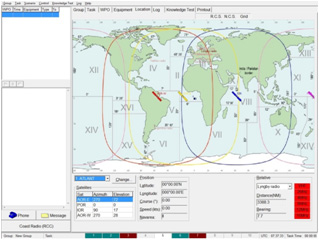
- Simulation of actual algorithm and time-tables of activity of the following coast radio stations ( in view of transmission traffic-list ):
- Argentina Radio
- Halifax Radio
- Lyngby Radio
- Saint-Lys Radio
- Rogoland Radio
- Scheveningen Radio
- Portishead Radio
- Bern Radio
- Possibility to create any coast radio station.
- Simulation of a system MARITEX.
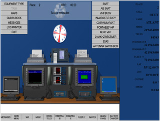
- Simulation of activity of EPIRBs (VHF, KOSPAS-SARSAT, Inmarsat-C) and SART.
- Indication of activity of the transponder (SART) on a screen of the radar.
- Simulation of permeability of radio waves in view of frequency, distance, time of day and season.
- Simulation of acoustic noise.
- Simulation of a signal “Free channel” and sound tracking of transmission of the information by radio telex


 Visit Today : 22 Visit Today : 22 |
 Total Visit : 57450 Total Visit : 57450 |